The ideal solution for covering large agricultural areas
The IRMA_SYS decision support system is continuously improved, having become an advanced smart irrigation system which, however, remains simple to use.
Based on internationally recognized models for calculating crop water requirements
It is the ideal solution for immediate coverage of large agricultural areas without requiring the installation of equipment in the field.
Utilization of measurements
It can utilize telemetry data from agro-meteorological stations and flowmeters.
Daily scale results
Calculation of daily water requirements taking into account parameters of soil, cultivation, and irrigation practices.
Services for Land Reclamation Organizations
Consolidated data for all the agricultural plots of an area for managers of large estates and land reclamation organizations
Decision supporting
Documentation of irrigation decisions in organic and integrated management systems and indications for environmental protection.
Data analysis
Detailed irrigation data enable farmers, agronomists, and researchers to evaluate the system and optimize yields.
Simple to use
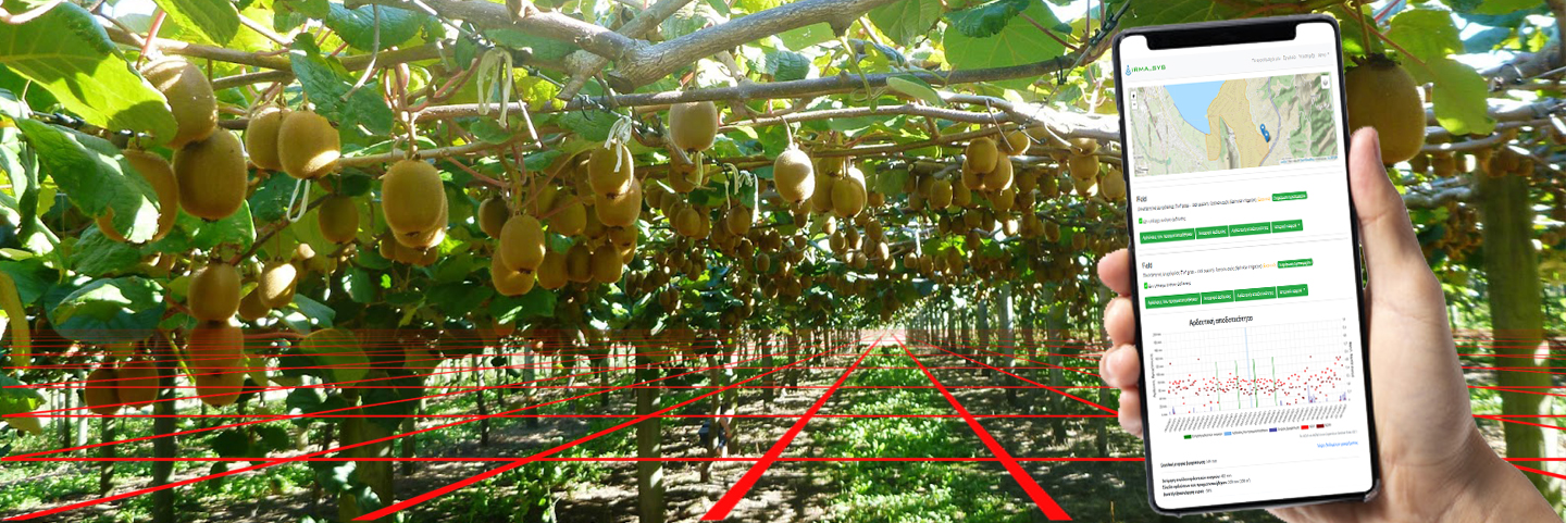
It provides immediate, easy-to-understand recommendations on when to irrigate and how much water should be used.
Installations
IRMA_SYS already covers more than 50.000 hectares of crops and is an ideal choice for land reclamation organizations and large agricultural enterprises.
LOLR: Local Organisation of Land Reclamation (Irrigation and Drainage Management Organisation)
- Western Greece
- Agricultural Cooperative Ilias Kipos / Pyrgos, 12.000 ha, processed tomato, turf grass (https://iliaskipos.irmasys.com/)
- Thessaly
- Municipality of Agia, 4.300 ha, apples, peaches, cherries, turf grass (under development 2026, https://dimosagias.irmasys.com/)
- Municipality of Farkadona, 1.000 ha, maize, cotton, alfalfa, wheat, turf grass (under development 2026, https://farkadona.irmasys.com/)
- Agricultural Cooperative of Melivoia – Athanati, 350 ha, chestnuts, turf grass (under development 2026, https://acmelivias.irmasys.com)
- LOLR Tavropos – Karditsa, 12.200 ha, cotton, maize (under development 2026, https://toevtavropou.irmasys.com)
- Central Macedonia,
- Plain of Giannitsa, 2.500 ha (GOLR Plains Thessaloniki – Laggadas / LOLR Kria Vrisi), cotton (https://toebkb.irmasys.com/)
- Western Macedonia
- Amyntaio, grape, 400 ha (under development 2026, https://asagiou.irmasys.com/)
- Sterea Ellada
- Copais, Experimental farm of AUA, maize, cotton, turfgrass (https://sah-aliartos.irmasys.com/)
- Epirus
- Municipality of Parga (LOLR Acheron / part 1.000 ha, maize, alfalfa, beans, turf grass (under development 2026, https://dimospargas.irmasys.com/)
- Municipality of Souli (LOLR Acheron – Gliki/ part 1.200 ha, maize, alfalfa, kiwi-fruit, citrus, turf grass (under development 2026, https://dimossouliou.irmasys.com/)
- Plain of Arta, 45.000 ha (LOLR Zone Aracthos, LOLR Lourou LOLR Grammenitsa – Vlacherna, LOLR Glikorizo, LOLR Peta-Kompoti, Municipality of Arta), olives, citrus, kiwifruit, grape, turf grass (https://arta.irmasys.com/, pre IRMASYS PC installation)
- LOLR Poros / basin of Ioannina, 1.500 ha, maize, alfalfa, turf grass (https://poros.irmasys.com/, pre IRMASYS PC installation)
Distinctions
- 2025, IRMA_SYS was awarded as one of best 3 proposals for the theme “Sustainable Water Management” of the Climate Neutral Cities Challenge (Greek Government / Ministry of Energy & Environment, Green Fund: https://climateneutral.mantisbi.io/)
- 2023, IRMA_SYS was short-listed for 20 innovative solutions for the agricultural sector and was presented at Accelerator Program for start-ups in the field of agriculture between China and the countries of Central and Eastern Europe which was organised by APAC (https://china2ceec.org/?lang=en)
- 2021, IRMA_SYS was accepted as good practice, from FAO (Food Agriculture Organisation) / ITU (International Telecommunication Union) in the framework of Regional Innovation Forum for Europe 2021 (page 54). Link
- 2019, IRMA_SYS was referred as CASE STUDY at FAO: Trendov, N. M., Varas, S., Zeng, M., 2019. Case study IRMA_SYS in Digital Technologies in agriculture and rural areas – Status report. FAO, Rome, Italy (page 102). Link
Documentation
“Selected as a case study and best practice by the ITU and the FAO”
Having its roots in a pilot application of 2008, and using open source code components that were developed by EU funded projects, IRMASYS has evolved to a complex system with a deceptively simple user interface.
Behind the scenes, meteorological stations upload their data to openmeteo.org and weather forecasts are made in openweathermap.org.
IRMASYS receives this data and performs aggregation and spatial integration, and calculates each field using state-of-the-art evaporation and soil water balance models.